The best real-time OSINT tracking tool for the Middle East just launched — and it was built by the team behind Caspian Report. Called Delta Sweep, it's a live intelligence dashboard that pulls together military aircraft positions, naval ship movements, GPS jamming signals, satellite feeds, oil infrastructure data, and a curated OSINT news feed into a single 3D interface. It's the kind of tool that used to require a government budget. Now it costs $6 a month.
What Is Delta Sweep and How Does It Work?
Delta Sweep is a real-time open-source intelligence (OSINT) dashboard purpose-built for monitoring the Middle East and the broader CENTCOM region. Shirvan, the host of Caspian Report and co-founder of the app, describes it simply: "You know how Batman has a massive computer sitting in his cave that shows all kinds of activity? This is that."
 01:45
The Delta Sweep 3D map interface showing live military aircraft positions across the Middle East
Watch at 01:45 →
01:45
The Delta Sweep 3D map interface showing live military aircraft positions across the Middle East
Watch at 01:45 →
The dashboard centers on a 3D interactive map that users can populate with live data layers. Want to see every military aircraft in the air right now? One click. Want to overlay GPS jamming hotspots, active naval deployments, and major oil infrastructure simultaneously? Done. The app pulls from ADS-B, MLAT, and other specialized data sources, with a deliberate focus on military assets rather than civilian traffic — a meaningful distinction from free alternatives.
The idea grew out of years of frustration. Shirvan's research workflow at Caspian Report once involved dozens of open browser tabs — flight trackers, ship trackers, satellite feeds, OSINT Telegram channels, geographic databases — all running in parallel. The cognitive load was unsustainable. So the team started building a system to consolidate everything, and over time, that system became Delta Sweep.
What Is OSINT and Why Does It Matter for Geopolitics?
OSINT stands for open-source intelligence — the practice of gathering and analyzing information from publicly available sources. That includes social media posts, satellite imagery, flight tracking data, ship transponder signals, news articles, radio intercepts, and much more. Intelligence agencies have used OSINT for decades, but it's become increasingly powerful for independent analysts as the internet has democratized access to real-time data.
04:10
GPS jamming overlay displaying red hexagon clusters — a key early warning indicator of military escalation
Watch at 04:10 →
In today's conflict environment, events are often live-streamed before governments issue statements. Drone strikes appear on Telegram before they appear on CNN. Unusual aircraft movements can signal diplomatic escalation hours before any official announcement. The challenge isn't access to information — it's filtering signal from noise at speed.
That's precisely what Delta Sweep is designed to solve. Rather than passively consuming geopolitical news, users can observe events unfolding in real time, draw their own conclusions, and develop genuine situational awareness. As Shirvan puts it: "By using our app, you will stop consuming geopolitics passively and start observing it unfold for yourself."
How Do You Track Military Aircraft and Ships in Real Time?
Delta Sweep's air tracking layer uses ADS-B and MLAT data — technologies that are more reliable for identifying military assets than standard civilian flight databases. When you click on any aircraft icon on the map, a popup immediately surfaces the call sign, speed, altitude, and aircraft type. Clicking further takes you to a dedicated page with even more detail about that specific platform.
06:30
Naval tracking view showing the USS Tripoli's position in the Arabian Sea alongside regional ship traffic
Watch at 06:30 →
Naval tracking works differently, because warships frequently disable their AIS transponders or spoof their positions to maintain operational unpredictability. This is where Delta Sweep does something genuinely novel: the team employs analysts who cross-reference logistics patterns, satellite imagery, and port activity to make informed assessments about likely naval positions. The result is that you can see ships like the USS Tripoli — an amphibious assault ship carrying 1,600 to 1,800 Marines — patrolling the Arabian Sea, even when the vessel isn't broadcasting its location openly.
The bases and ships layer also shows static military installations, with data on the equipment and assets hosted at each base. Click on a base in Qatar, for example, and you'll see which aircraft types, helicopters, and hardware are stationed there. Click on any piece of hardware and you get a full explainer on that weapons system. It's the kind of reference layer that turns a map into a briefing document.
What Does GPS Jamming Tell Us About Imminent Conflicts?
One of the most analytically powerful features in Delta Sweep is its GPS jamming overlay. Modern aircraft depend heavily on satellite navigation, and when those signals are deliberately disrupted, it shows up as interference clusters on the map — visualized as red hexagons.
08:55
Resource layer highlighting Kharg Island and Iran's oil infrastructure across the Persian Gulf
Watch at 08:55 →
Shirvan explains that at Caspian Report, GPS jamming patterns are one of the first indicators the team monitors during periods of diplomatic tension. When large clusters of red hexagons appear simultaneously in a region, it often means military activity is imminent or already underway. It's a leading indicator, not a lagging one — which is exactly the kind of edge that Delta Sweep is built to provide.
Why Is Kharg Island the Linchpin of Iran's Economy?
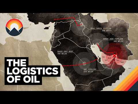
Delta Sweep's resource layer maps every major refinery and processing facility across the CENTCOM region — and one location stands out above all others: Kharg Island, located in the northern Persian Gulf.
Here's why it matters. The Persian Gulf is a shallow body of water, particularly along its coastline. Standard oil tankers require 25 to 30 meters of depth for safe navigation, and much of the Gulf simply doesn't meet that threshold. As a result, Iran extracts and refines crude oil near its mainland fields, then funnels it via pipeline to Kharg Island — the one location where the water is deep enough for large tankers to dock. From Kharg, Iranian oil enters the global market. It is, in practical terms, Iran's only viable route for seaborne oil exports.
That single point of vulnerability makes Kharg Island a critical strategic target — and also helps explain U.S. naval posture in the region. But seizing it would be extraordinarily costly. Iran can strike from the mainland using drones, ballistic missiles, and fast-attack boats, meaning that control at sea doesn't translate to control of that island.
What Are Fiber Optic Drones and Why Can't America Jam Them?
Among the more alarming details Shirvan discusses is Iran's deployment of fiber optic drones — short-range tactical unmanned systems guided by physical cables rather than radio signals. Because they don't rely on wireless communication, they are effectively immune to electronic jamming, which is one of the primary countermeasures used against conventional drones.
Some of these cable systems extend up to 60 kilometers — more than enough range to cover every Iranian island in the Persian Gulf. Launched in swarm numbers, they could overwhelm any amphibious landing force. Shirvan puts it bluntly: imagine one drone for every Marine deployed to the region. That threat calculus is likely a significant factor in why the United States has remained reluctant to commit ground forces to the area.
Can You Get a CIA-Style Dashboard for $6 a Month?
Delta Sweep currently costs $6 per month on the annual plan, with a 7-day free trial at sign-up. There are no feature caps and no restrictions — everything described above is included. Shirvan is transparent that the price will increase as new features are added, and that early subscribers who lock in within the first 30 days will retain that $6 rate indefinitely as long as their account stays active.
Upcoming features include crowdfunded satellite imagery purchases, expanded regional coverage for Ukraine and Taiwan, and additional data layers. The commercial model exists not just to sustain the platform — licensing costs for real-time data feeds are substantial — but also to democratize the kind of intelligence toolkit that was previously accessible only to governments and well-funded newsrooms.
For anyone serious about understanding how the world actually works — not through the filter of slow-moving headlines, but through live data — Delta Sweep is worth a serious look. Visit deltasweep.com to start your trial.