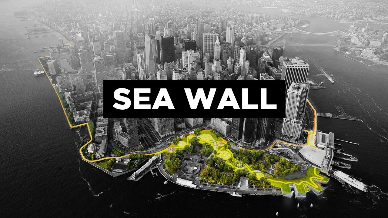

New York City is protecting itself from flooding through one of the most ambitious and expensive infrastructure programs ever proposed for any city on Earth. Since Hurricane Sandy devastated the region in 2012, New York has been quietly retrofitted — steel flood doors now seal subway tunnels, critical mechanical systems have been moved to the tops of skyscrapers, and a $119 billion mega sea wall has been proposed to shield more than 25 million people from catastrophic storm surge. That wall may look like science fiction, but it is very much a real plan, and construction of the broader flood-defense system is already underway.
What Damage Did Hurricane Sandy Cause to New York?
To understand why New York is spending billions on flood defense, you have to go back to October 29, 2012. That's the day Hurricane Sandy made landfall and fundamentally changed how the city thinks about water.
 01:15
Graphic showing the proposed mega sea wall stretching nearly 10 kilometres from the Rockaways in Queens to New Jersey, south of Staten Island
Watch at 01:15 →
01:15
Graphic showing the proposed mega sea wall stretching nearly 10 kilometres from the Rockaways in Queens to New Jersey, south of Staten Island
Watch at 01:15 →
The numbers are staggering. Sandy's storm surge flooded approximately 17% of New York City's entire footprint. Around 2.5 million residents lost power. More than 35,000 people were displaced in forced evacuations. At least 286 people were killed, either directly or as a result of the storm's aftermath.
Seawater poured into Lower Manhattan. Subway tunnels became rivers. Electrical systems in the city's iconic skyscrapers fried within minutes of basements flooding, plunging entire blocks into darkness. Tens of thousands of homes were damaged or destroyed.
The final bill came to more than $19 billion in physical damage and lost economic activity. The storm didn't just break infrastructure — it exposed just how vulnerable a city built largely at or near sea level really was. New York had to go back to the drawing board.
03:40
Archival and illustrative footage showing the scale of Hurricane Sandy's flooding across New York City in October 2012
Watch at 03:40 →
How Is New York City Protecting Itself From Flooding?
The federal government responded by tasking the US Army Corps of Engineers with figuring out how to prevent a Sandy-scale disaster from ever happening again. The result was a sweeping, multi-layered flood-defense strategy that operates on several scales at once — from massive harbour-spanning barriers down to redesigned public parks.
Some of these changes are already invisible parts of daily life. Steel doors now deploy across all tunnels under the city during storm events. Critical mechanical floors in skyscrapers have been relocated from basements to upper floors. East River Park has been rebuilt 8 feet higher than its original grade. Battery Park at the southern tip of Manhattan has been raised and reinforced with sea walls and flood barriers designed to handle up to 6 feet of sea-level rise through 2100.
But the centrepiece of the long-term plan is something far more dramatic.
What Is the New York Mega Sea Wall Project?
The Army Corps of Engineers didn't just propose one solution — they put forward five. But the most radical, and the one that captured the world's attention, was the proposal for a mega sea wall so large it needed its own classification.
06:20
Comparison graphic showing how the Thames Barrier's retractable gate system works, illustrating the same principle proposed for New York Harbour
Watch at 06:20 →
The original concept involved a nearly 10-kilometre-long barrier stretching from the Rockaways in Queens to a strip of land in New Jersey, south of Staten Island. It wouldn't be a single solid wall but rather a network of man-made islands with retractable gates — large storm-surge barriers, floodwalls, levees, and nature-based defences anchored by five major harbour-scale barriers at strategic chokepoints.
Think of it like the Thames Barrier in London or the famous sea walls in Rotterdam — except much, much bigger. During normal conditions, the gates would lie flat, allowing ships, tides, and marine ecosystems to function normally. During a major storm, they would rise to form an impenetrable barrier. Within its protected boundary would sit much of Manhattan, including the Statue of Liberty.
The original price tag? $119 billion.
Why Are Critics Calling the Mega Sea Wall a Blunt Solution?
Not everyone is convinced a giant wall across New York Harbour is a good idea — or even a workable one.
Critics point out that the wall would only protect against storm surges, not the steady creep of everyday flooding from high tides and stormwater runoff that comes hand-in-hand with rising sea levels. That's a significant gap in protection for a city that will face both threats increasingly in the coming decades.
11:50
Render showing the East Side Coastal Resiliency project's elevated park landscape and integrated flood gates along the East River
Watch at 11:50 →
There's also a deeply unpleasant environmental concern. The Natural Resources Defense Council has warned that during heavy rain events, stormwater and sewage systems can back up, sending waste into waterways. A closed sea wall could trap that waste and push it back toward shore — essentially turning New York's harbour into a toxic swamp during the very moments it's needed most.
Beyond that, the barriers would alter the natural currents of the Hudson River, with potentially serious consequences for wildlife and marine ecosystems. And the engineering challenges are immense — any barrier would need to withstand Category 3 hurricanes, debris, shipping impacts, ice, and sea-level rise projected all the way through 2100, all while building in redundancy for potential failure.
There's also the small matter of political approval. A project like this would require sign-off from New York City, New York State, and New Jersey — all of whom would be expected to cover 35% of the cost. The remaining 65% would need Congressional approval. Getting all of those stakeholders aligned is, to put it mildly, a challenge.
What Is Alternative 3B and When Does Construction Start?
After years of public hearings and fierce debate, the Army Corps released the New York-New Jersey Harbor and Tributaries Study in 2022 — the result of more than a decade of sea-level rise modelling and coastal flood analysis. The report included a revised, scaled-back plan.
Instead of a $119 billion mega-wall built all at once, the new approach — officially called Alternative 3B — brings the cost down to $50–53 billion and breaks the project into smaller, more manageable segments. This includes roughly a dozen movable storm-surge gates at key waterways around New York and New Jersey, alongside dozens of kilometres of shoreline barriers, raised seawalls, levees, and elevated promenades.
Construction is tentatively scheduled to begin in 2030, with the revised plan estimated to take a decade rather than the original 25 years. Smaller, more immediate measures that don't require full federal funding upfront will be prioritised first, with the possibility of integrating them into the larger system if the full plan eventually moves forward.
What Is the East Side Coastal Resiliency Project?
While the mega sea wall debate continues, one of the most impressive flood-resilience projects in the United States is already reshaping Manhattan's edge — and it looks nothing like a wall.
The East Side Coastal Resiliency project (ESCR), designed by Bjarke Ingels Group (BIG), stretches roughly 3.8 kilometres along Manhattan's East River from Montgomery Street to East 25th Street. At a cost of around $1.45 billion, it's one of the largest climate-resilience investments New York City has ever made.
Rather than separating the city from the river with a hard barrier, BIG's design creates a continuous series of elevated green islands, promenades, parks, sports fields, gardens, and play areas that are engineered to double as a flood-protection system. Deployable flood gates are integrated into the landscape itself, invisible when not in use but capable of sealing off the area when a storm threatens.
The centrepiece is East River Park, which is being entirely rebuilt as a raised landscape elevated by 2.5 to 3 metres — high enough to block projected storm surge well into the future. Thousands of mature trees have been removed, stored, and will be replanted. Construction began in 2021 and will continue through the mid-2020s.
ESCR represents a philosophical shift in how cities think about flood risk. It's not about fighting water — it's about redesigning urban life to coexist with it.
Will New York City Flood Again in the Future?
Almost certainly — the question is how badly, and how prepared the city will be when it does. Climate scientists broadly agree that sea levels will continue to rise and that extreme storm events will become more frequent and more powerful as global temperatures increase. The Army Corps' own models project significant sea-level rise through 2100, and critics have argued those projections may still be too conservative.
New York isn't alone in facing this challenge. Nearly 58% of the global urban population lives in coastal cities, and the solutions being developed in New York — mega barriers, elevated parks, nature-based flood defences — are likely to become blueprints for cities around the world.
There's even a more radical idea on the drawing board: Mannahatta, a concept proposed by an economics professor at Rutgers University that envisions an entirely new borough dredged from the sea to provide flood relief and address New York's skyrocketing property prices. For now, it remains firmly conceptual.
What isn't conceptual is the scale of investment already underway. Between Battery Park, ESCR, Governor's Island, retrofitted tunnels and skyscrapers, and the long road toward Alternative 3B, New York is betting billions that it can hold back the sea. Whether that bet pays off may be the defining infrastructure story of the 21st century.