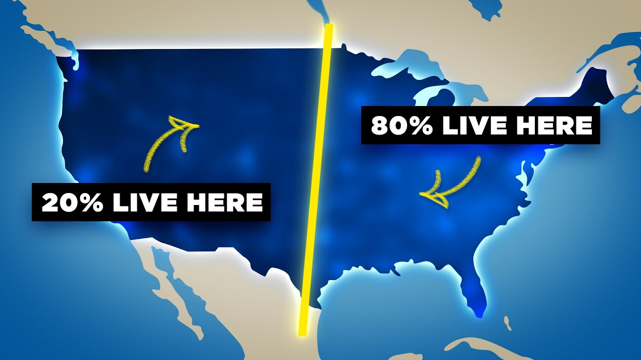

The American West is so empty because it simply doesn't rain enough to support large-scale human settlement. An invisible boundary running roughly along the 98th Meridian divides the United States into two radically different worlds: a densely populated east where 80% of Americans live, and a vast, near-empty interior where only one in five Americans exist — and most of those are clustered in a handful of desert cities. This isn't a coincidence or a quirk of history. It's geography, climate, and water — or rather, the lack of it.
Why Is the American West So Empty?
Look at a population density map of the United States and one thing jumps out immediately: there's a sharp, almost perfectly vertical line running north to south through the middle of the country. To the east of it, cities and towns blur together in a nearly continuous chain of light. To the west, there's mostly darkness — vast stretches of land with almost no one in them.
That boundary runs through or just west of cities like San Antonio, Oklahoma City, Wichita, Omaha, Sioux Falls, and Fargo. These aren't random cities — they are, quite literally, the last outposts before the frontier begins. An overwhelming 260 million Americans — about 80% of the total population — live to the east of this line. The remaining 20% are spread across a territory that makes up the majority of America's landmass.
And before you think California throws this all off: yes, California has nearly 40 million people, but the vast majority of them live in a narrow coastal strip pressed up against the Pacific Ocean, squeezed between the ocean and the towering Sierra Nevada mountains. Strip away California's coastal population and the interior American West — an area roughly the size of the entire European Union — is home to only about 30 million people. That's comparable to the population of the greater New York City metro area alone. Of those 30 million, a third live in just three cities: Phoenix, Denver, and Las Vegas.
What Is the 98th Meridian and Why Does It Matter?
The 98th Meridian is a line of longitude that bisects the continental United States from north to south. It's not marked on any road sign, but it shows up in almost every map depicting American life — from fast food accessibility to tree species diversity to linguistic quirks like whether you call a firefly a "lightning bug."
The reason this invisible line appears so consistently across such wildly different maps is simple: it tracks the boundary between wet America and dry America. To the east of it, rainfall is reliable enough to support dense forests, large-scale agriculture, and big cities without requiring complex water infrastructure. To the west, rainfall is scarce, unpredictable, and insufficient for the same.
The line was first identified not at the 98th but at the 100th Meridian, by a 19th-century geologist named John Wesley Powell. Since his time, the line has crept about two degrees eastward — a shift that has enormous consequences for the tens of millions of Americans who live along it.
Why Does It Rain So Much Less in the American West?
The rainfall difference across this line is dramatic. Dallas, just east of the boundary, receives about 38 inches of rain per year. Abilene, to the west, gets 26 inches. Midland, further west still, gets just 15. The same pattern repeats from Texas all the way to North Dakota: Oklahoma City gets 33.5 inches while Amarillo gets under 20; Wichita gets 34 inches while Dodge City, just a bit to the west, gets 19.
The reasons are geographic. The eastern United States gets moisture from two major sources: Atlantic storms that roll in from the east, and Gulf of Mexico moisture that surges northward in summer. The Appalachian Mountains — the main range in the east — are relatively short, with their highest peak at just under 6,700 feet. They do almost nothing to block incoming moisture, which is why the eastern US stays reliably wet year-round.
The western interior, by contrast, is cut off from the Pacific Ocean by some of the most formidable mountain ranges on Earth — and that's where the rain shadow comes in.
What Is the Rain Shadow Effect and How Do Mountains Cause It?
A rain shadow is what happens when a mountain range blocks moisture-laden air from passing through. As air rises over a mountain, it cools, and that cooling causes it to drop its moisture as rain or snow on the windward side. By the time that air descends on the other side of the mountain, it's dry — and the land beneath it gets almost no precipitation.
The Rocky Mountains — the third longest mountain chain in the world, stretching more than 3,000 miles with peaks reaching 13,000 to 14,000 feet — cast an enormous rain shadow across the American interior, blocking the vast majority of Pacific moisture from reaching the plains. But the Rockies aren't alone. The Cascades in the Pacific Northwest, the Sierra Nevada in California, and the Klamath and Transverse ranges all pile on, creating a nearly impenetrable wall against incoming Pacific weather systems.
The result is staggering. Seattle, on the wet side of the Cascades, receives 37 inches of rain per year. The small town of Mattawa, just over the mountains to the east, receives just 4.5 inches — about the same as Las Vegas. That difference exists within the same state, separated by a single mountain range.
Who Was John Wesley Powell and What Did He Predict?
In 1878, geologist and explorer John Wesley Powell — the second director of the United States Geological Survey — became the first person to formally identify and document the dry line across America. As he traveled westward, he noticed that plant diversity dropped sharply at a consistent longitude. He traced the cause to rainfall and drew his boundary at the 100th Meridian.
But Powell didn't just identify the line — he issued a warning. He went to Congress and argued that the settlement of the American West would have to be fundamentally different from the settlement of the East. Without reliable rainfall, western development needed to be planned carefully around the region's watersheds — natural drainage basins where water collects and flows to a common outlet.
Powell even proposed redrawing the political boundaries of western states to align with these watersheds, so that water management could be handled cooperatively rather than through competing state interests. Congress ignored him. The political boundaries stayed as they were, carved out of maps with rulers rather than rivers, and the water crisis Powell predicted has now arrived — a century and a half later, more or less exactly as he described.
Is the Colorado River Really Drying Up?
Yes — and it's serious. The Colorado River is the lifeline of the American West, supplying fresh water to roughly 40 million people across seven states and parts of Mexico. It feeds cities like Las Vegas, Phoenix, Los Angeles, and San Diego. It powers agriculture across the entire region.
For the first time in recorded American history, the federal government has been forced to cut the amount of water states are allowed to withdraw from the river. The river is already so thoroughly tapped that it no longer even reaches its natural delta at the Gulf of California — every drop is used up or diverted before it gets there. Further cuts are likely in the years ahead, and the situation is being described by scientists as potentially the worst drought the region has seen in thousands of years.
How Is Climate Change Shifting the Dry Line East?
Here's where things get alarming. The dry boundary that Powell identified at the 100th Meridian in 1878 has already shifted roughly two degrees east to around the 98th Meridian today. And it's continuing to move east as global temperatures rise and rainfall patterns shift.
Cities like San Antonio, Oklahoma City, Wichita, and Fargo — the frontier cities that sit right on that boundary — are beginning to see less reliable rainfall. Farms in the region are being forced to adopt irrigation techniques they never needed before. Crops that once thrived, like corn, are being replaced by more drought-resistant alternatives like wheat. Many farms are failing or being consolidated.
The empty third of America is getting drier. The cities on its eastern edge are feeling the pressure. And the water infrastructure of the entire western United States — already stretched beyond its limits — is being asked to do even more with even less.
John Wesley Powell saw all of this coming in 1878. The politicians of his day didn't listen. The question now is whether the ones in ours will.